
In France and in the world, paragliding is to Saint Hilaire du Touvet what mountaineering is to Chamonix. Thanks to the Coupe Icare which takes place every year, this spot is one of the most famous in the world…of paragliding !
You want to go paragliding in Saint Hilaire du Touvet ? You are looking for information to make a tandem flight ? or offer a tandem flight ? realize a course ? fly on the spot with your equipment ? Don’t look any further because this is where you will find the answer to all your questions 😉
Tandem flight, courses, informations on take off and landings, cross country topo, hike and fly, clubs, etc…I will try to give you all the information you need to make your stay in Saint Hilaire as pleasant as possible 😉
Located near Grenoble in the Chartreuse mountains, the village of Saint Hilaire du Touvet welcomes paragliders from all over the world! Since 1976 and the 1st edition of the Coupe Icare, the reputation of the site is well known. Indeed, the whole paragliding world gathers in Saint Hilaire on the third weekend of September to discover the new products of the manufacturers, to attend the Icares of the cinema and especially to celebrate :D. If you want to know more, visit the Coupe Icare website
Thus, in Saint Hilaire, everything is combined to make your visit a magical moment :
- Paragliding schools and professionals supervise you for tandem flights and courses
- 3 official take-offs, including a carpeted take-off, put you in the best flying conditions
- A landing worthy of an aerodrome allowing you to land in complete serenity
- Conditions often ideal for long distance flights and for covering many kilometers (thanks to the East faces of Chartreuse!)
- A funicular providing the ascent (practical for the rotation) towards the paragliding departures. The “funi” is open from spring to autumn, on weekends during the low season and then all week during the high season. You should consult the schedule for more information: here is the link
- Paragliding stores with expert advice on products
- The possibility to have your wing controled and repaired
- Bars and terraces to contemplate the sky and enjoy the special atmosphere of the site: after the effort, the comfort, right?
- Not to mention a breathtaking view of the Chartreuse, the Belledonnes and the Vercors: personally I never tire of it!
Here is an overview of the possibilities, as well as all the practical information for paragliding in Saint-Hilaire du Touvet.
Pagalgiding tandem flight in Saint Hilaire du Touvet
The different paragliding tandem flights in Saint Hilaire and the price
First of all, if you want to know more about the different types of paragliding baptisms, I invite you to read my article on the subject : the different tandem flights in france. You will find detailed information on how to do a tandem, who can do it, the average price, what to wear… This will surely help you to make your final choice.
In the meantime, if you want to make a paragliding jump in Saint Hilaire du Touvet, here is a summary of what you can find :
Kids flight (on morning time)
- From 3 to 14 years old depending on the structure
- Average duration : 10 minutes
- Average price : 75€ (€
Discover flight (on morning time with quiet conditions)
- From 14 years old
- Average duration : 10/15 minutes
- Average price : 90€ (€)
Thermal flight (on afternoon time, with thermal conditions)
- From 14 years old
- Average duration : 20/30 minutes
- Average Price : 110€
Be careful if you have motion sickness, opt for a discovery flight, this flight may shake you up slightly.
Sensational flight with acrobatics with acrobatics tricks. Late morning and afternoon, also in thermal conditions. You have to like strong sensations and have a good heart!
- From 14 years old
- Average duration : 20/30 minutes
- Average price : 110€
During the flight
Now that you know the differences, concretely, what are you going to do as a flight in Saint Hilaire du Touvet ? Well, close your eyes for a while… 😀 Let yourself be guided :
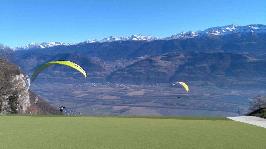
You are just in front of the Belledonne mountain range, so beautiful to contemplate while your instructor gives you the advice to take off. After the magic moment of the take-off, you discover a feeling of freedom specific to the practice of paragliding. Time stops for a few minutes and your pilot takes you to observe the magnificent landscapes of Chartreuse :
- The Oule waterfall, just below the takeoff, which flows in the middle of large limestone cliffs
- The plateau des petites Roches : if you fly in thermal conditions, you fly over the take off, the village of Saint Hilaire and the surrounding villages. You have a splendid view on the Dent de Crolles which dominates the massif at this place.
- The valley : after the walk above the plateau, you go to the valley where you can admire the view on Grenoble, the Sept Laux and the Vercors. At this moment, the instructor will give you an initiation to piloting if you wish and/or will propose you to do some acrobatics before landing gently, like a little flower, on the official landing site located in Lumbin.
Déco Sud 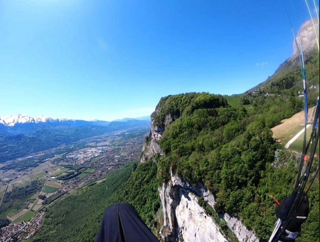
Vue sur la cascade et le déco Nord (moquette) 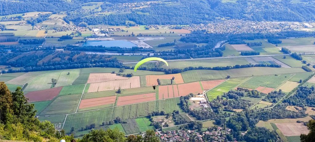
Vue sur la vallée
Where to do your tandem flight around Saint Hilaire du Touvet?
You will find many structures allowing you to make your first paragliding flight in Saint Hilaire. In fact, a world-renowned site means an influx of tourists, and means supply and demand 😉
Paragliding schools as well as structures specialized in tandem flight offer these activities. Whatever happens, you are always accompanied by an instructor with a state certificate. That’s pretty reassuring, isn’t it ?
You will find below a list of organizations identified for the practice of tandem flight in Saint Hilaire :
Based in Lumbin (landing area)
Based in Saint Hilaire (take off area) :
- Prévol Parapente : close to the funiculaire arrival
- Air Alpin just behind hthe church
- Biplace Parapente
Around Grenoble :
I invite you to contact them to check their availability. Please note that the periods of high activity are naturally linked to the weather: between June and September, it will be necessary to anticipate a little.
Paragliding courses in Saint Hilaire du Touvet
The different paragliding courses in Saint Hilaire du Touvet and the price
Along with paragliding tandem flights, if there is one thing that is famous in Saint Hilaire du Touvet, it is the paragliding course! Personnally, I learned paragliding there ;). On this mythical and ancestral spot also, many pilots made their weapons. So if you want to learn paragliding, Saint Hilaire is the right place !
I have written an article where I detail the different types of paragliding courses (program, average price, etc.) and I invite you to read it to know more : the different paragliding courses.
If you don’t have the time, here is a summary of what you can find for courses in Saint Hilaire :
Initition course
- From 14 years old / For beginners who have never paraglided before.
- Discovery of the material / theory lessons / school slope / first solo flights!
- Price : 450€ – 700€ between 3 to 5 days
Progression course
- After having done a course for beginners / For pilots who are a bit rusty
- Flying on a known site / repeating flights / knowing how to analyze the conditions / becoming AUTONOMOUS!
- Price : 400€ – 800€ between 2 to 5 days
Improvement course
- After the progression course / for pilots who wish to discover new sites while being supervised
- Fly on new sites / improve your analysis (aerology, terrain typology) / perfect your piloting with flight and ground exercises / fly in thermals / pass the initial pilot’s license
- Price : 300€ – 800€ between 2 to 5 days
Cross country course
- For pilots who want to push their limits (flight time / distance)
- Improve pre-flight and in-flight analysis (aerology, site selection analysis / airspace information) / fly in thermals / work on positioning, speed, transitions
- Price: 130€/day on average.
Single surface course
- For mountain enthusiasts / sporty people
- pre-flight analysis (choosing the right summit, the right orientation according to the weather) / analysis on site / learning the necessary gestures for take-off and landing
- Price: from 550€ for 4 days.
Where to do your paragliding course around Saint Hilaire du Touvet ?
As for paragliding tandem flights, paragliding schools as well as independent trainers are the main organizations to realize a paragliding course in Saint Hilaire. Here is a list of the different structures identified with the courses proposed by structure :
- Air et Aventure Académie : all courses available
- Prévol Parapente : all courses available except the single surface one
- Air Alpin : all courses available except crosscountry
- Saint Hilaire School : all courses available except cross country and single suface
- Air2ailes : all courses available except cross country and single suface
Do not hesitate to contact them for availability and rates. Be careful, the courses fill up quickly between May and July, you will have to book a little earlier.
Saint Hilaire du Touvet flying spots
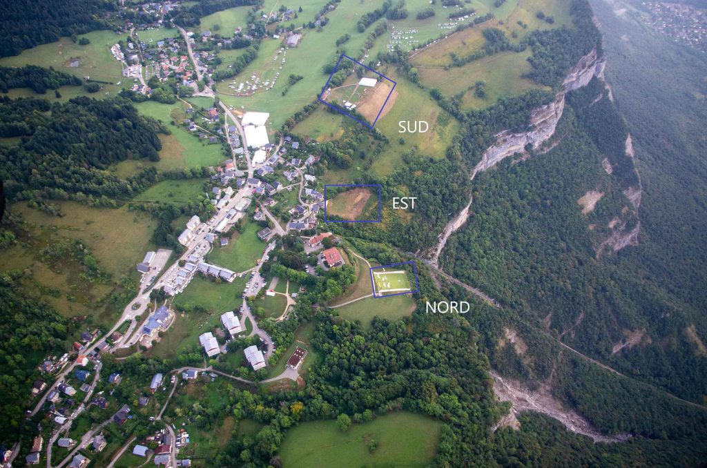
For the greatest comfort of paragliders, Saint Hilaire du Touvet offers 3 first-class take-offs, with slightly different orientations :
- North take-off : carpeted take-off
- East take-off : grass
- South take-off : also in grass
All these takeoffs lead to the same landing: the landing of Lumbin.
You can find all weather forecast information about Saint Hilaire here.
Here are the different paragliding departures in Saint Hilaire du Touvet.
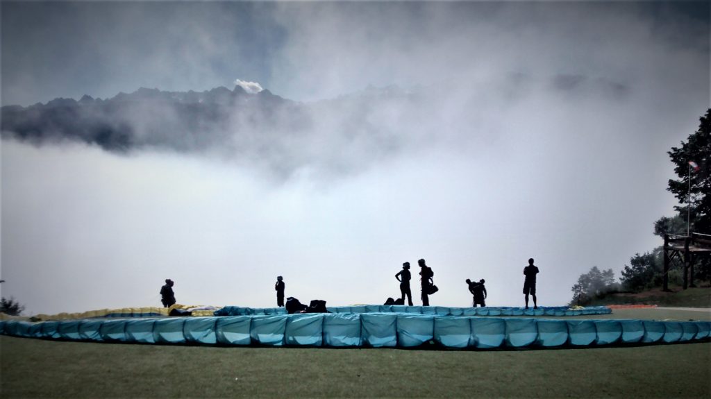
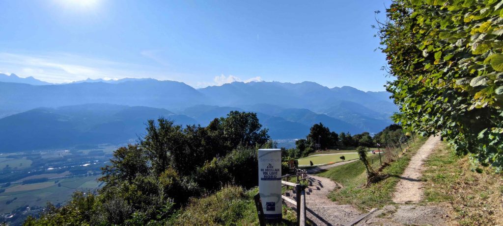
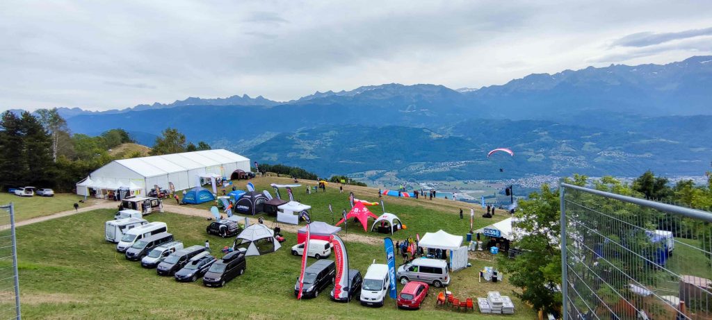
NORTH TAKEOFF
It is the most comfortable paragliding departure point, the one where we see all the paragliders taking off during the Coupe Icare.
Information NORTH take off Saint Hilaire :
| Orientation OK | EAST / SOUTH EAST / SOUTH / SOUTH WEST |
| Orientation NOK | STRONG NORTH / WEST / NORTH WEST |
| Level to take off | EASY on morning but be careful on thermals during spring and summer (starts around noon) |
| Type of flight | THERMALS / CROSS COUNTRY DEPARTURE |
| Take off altitude | 890m |
| Altitude difference with landing | 650m |
NB : Possible takeoff with weak North East / North West (less than 15km/h on the beacon of the South takeoff), which can be synonymous of the rise of the breeze at the level of the takeoff or of a meteorological wind of north. A good analysis remains to be done on site. Otherwise, the school slope located behind the south takeoff will welcome you for a good inflation session.
Access to the North take off of Saint Hilaire :
By car : Once in Saint Hilaire du Touvet, follow the funicular signs. The take-off is located next to the arrival station.
By funiculaire : The departure is located at the arrival station. It couldn’t be more convenient.
EAST TAKE OFF
It is the last paragliding departure to be born in Saint Hilaire du Touvet. It is also located next to the funicular, on the Pal de Fer trail. It is perfect to take off when you walk up from the landing (it is the first one on your way) or when the North launch is too crowded (between trainees and tandem pilots).
Informations EAST take off Saint Hilaire :
| Orientation OK | EAST/ SOUTH EAST |
| Orientation NOK | NORTH / NORTH EAST / WEST / SOUTH WEST / NORTH WEST |
| Level to take off | EASY on morning but be careful on thermals during spring and summer (starts around noon) |
| Type of flight | THERMALS / CROSS COUNTRY DEPARTURE |
| Take off altitude | 921m |
| Altitude difference with landing | 680m |
NB : Beware of the sails coming out of the North deco, as well as the thermal at the exit of the take off which can be strong (from noon)
Access to the EAST take off of Saint Hilaire :
- By car : Park in Saint Hilaire on the main parking lot, next to the tourist office. Then walk to the Pal de Fer path, passing behind the church.
- By funiculaire : from the arrival station, turn right and pass behind the church to reach the take-off area located a little further on.
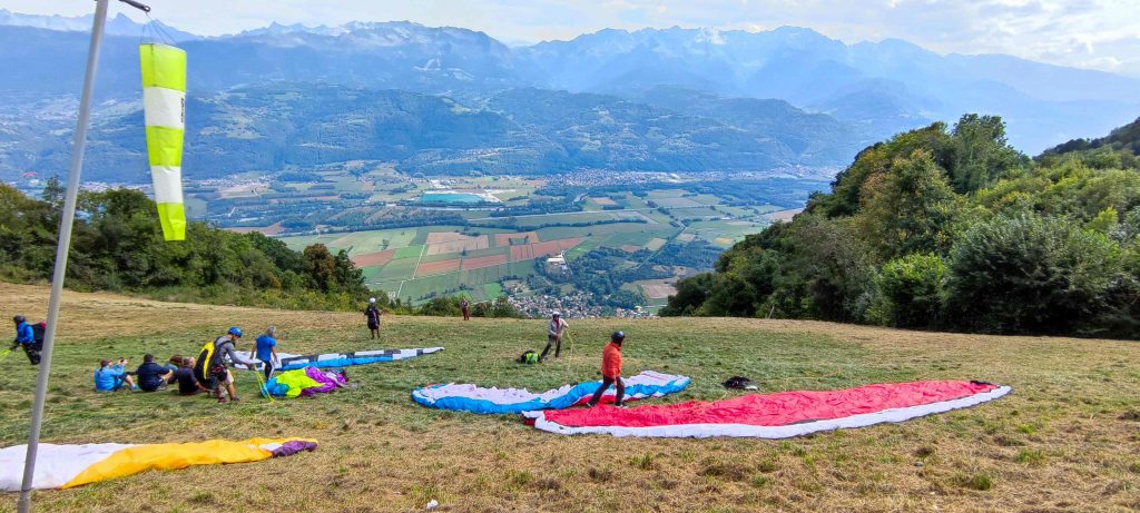
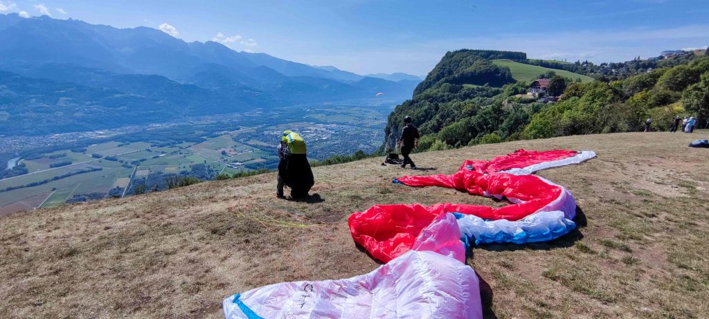
SOUTH take off
It is the most frequented takeoff of the cross countryers, they will recognize themselves. It is also the biggest with room for dozens and dozens of wings (in preparation AND at the slope). It is also well equipped with tables to eat and a public toilet, like a 5 stars accommodation !
Information SOUTH take off Saint Hilaire :
| Orientations OK | EAST/ SOUTH EAST / SOUTH / SOUTH WEST |
| Orientations NOK | NORTH / WEST / NORTH WEST |
| Level to take off | EASY on morning but be careful on thermals during spring and summer (starts around noon) |
| Type of flight | THERMALS / CROSS COUNTRY DEPARTURE |
| Take off altitude | 940m |
| Altitude difference with landing | 700m |
NB : Downwind takeoff in a northerly regime.
Access to the SOUTH take off of Saint Hilaire :
- By car : Park in Saint Hilaire on the main parking lot, next to the tourist office. The take-off is just behind by taking the path that goes straight there.
- By funiculaire : From the arrival station, go up the path towards the tourist office. Then follow the path that leads to the take-off.
- You want to know how is the wind in real time? check-it out !
Landing in Lumbin
Access to the Landing area of Saint Hilaire du Touvet :
- Waze access : “Atterrissage parapente Lumbin”
- From Grenoble: Take the A41 to Crolles. Exit at Crolles and take the D1090 towards Lumbin. At the entrance of the village, turn right at the roundabout. A large parking lot is located just behind the landing.
- From Chambéry: take the A41 to Le Touvet or the D1090 if you don’t want to pay tolls 😉 Continue from Le Touvet on the D1090 to Lumbin. At the exit of the village, turn left at the roundabout. A large parking lot is located just behind the landing.
Landing in Saint Nazaire
Acess to the landing area of Saint Nazaire :
- GPS coordonnates : 45.266000, 5.841600 (alt: 459m)
The different paragliding clubs in Saint Hilaire du Touvet
There are several paragliding clubs in Saint Hilaire and its surroundings. Here is a listing of the FFVL clubs with the information I found on the net: contact, website, activities. If you are looking for a club, make your choice!
If you’ve ever participated in the Coupe Icare, then you’ve probably met a few club members at the bar at the south deco, the barateam, which the volunteers run with a masterful hand 😉
Created in 2000, the club has more than 200 members and shows a nice mix: young, old, men, women.
Based in Grenoble, the DUCK gathers a large community of paragliders. It is known, according to its president Mickey, for 2 things: the disguises for the Coupe Icare where he has a nice delegation of braggarts and the week of flying organized at the Dune du Pilat. Enough to have a good slice !
It is the oldest club around Saint Hilaire. A very friendly club which also offers different types of outings
The CHVD is the club which manages the landing of St Nazaire les Eymes, just below the combe de Manival. Among other activities of the club, I invite you to visit their website which contains very interesting information on cross country, flight randos, and flight stories in the vicinity of Saint Hilaire.
Ideas for cross-country paragliding from Saint Hilaire du Touvet
With its well-lit eastern faces, Saint Hilaire du Touvet is a landmark for all the croakers of the area during the working days. From spring to autumn, cross-country skiing is one of the main activities of the spot! The days when it is smoky, you can also cross beautiful people on the decos, sign that you are in the good place, at the good time :D.
The best pilots or the most daring pilots (sometimes it’s both at the same time) can take off very early, from 10:30 am. Knowing this, you can choose your time slot.
Please note before continuing : some of the information you will find below is given as an indication. Everything depends on your equipment, your level of flying and your knowledge of the weather. Do not neglect these points, as well as the weather analysis before and on the day. Think of it more as an aid to visualize the cross country or as a starting point for a reflection that must be more thorough.
Now that everything is clear, you will find below some ideas for cross-country trips from Saint Hil’.
Go and back to the Saint Eynard
It is the starting point of the majority of the cross-country trips made from Saint Hilaire.
From the take off, head south (Grenoble) along the limestone cliffs to the first point called “les antennes”. Still following the cliffs to the south, you arrive at the first “lock” of this cross at the combe de Manival. Make sure you stay on the foreground (do not enter the combe) to refuel and to be high enough (1400m approximately) before making the mini transition and continuing your way. You will then arrive at the Fort du Saint Eynard where you will surely find a nice thermal on the south side.
From there you can turn around and take the same way back to land at Lumbin or Saint Nazaire (at the foot of Manival).
To give you an idea…
I have compiled for you some traces that can help you :
A/R Saint Eynard :
More traces : https://ayvri.com/explore?q=saint%20eynard
Par le Granier
Plus de traces : https://ayvri.com/explore?q=saint%20eynard%20granier
To continue the adventure : the different options from the Granier.
1. Transition to Belledonne
From the Granier, even a little bit before at the level of the Alpe pass or the Aulp du Seuil (minimum 2000m), you have the possibility to go towards the Belledonne massif in the direction of Saint Genis. Don’t hesitate to make a nice dog-leash so that you don’t get too much drifted by the valley breeze. You have no flight restrictions if you take this route. Once you have hung up the Saint Genis, either you follow the foreland before crossing the valley again (1200m mini) and land in Lumbin, or you can go for a walk in the massif, passing over the 7 Laux, the Grand Replomb, the Grande Lance de Domène and enjoy a breathtaking view over the lakes.
Variation to lengthen by passing through Belledonne
2. From the Chartreuse, transition to the Bauges then return through the Belledonnes
Still from the Granier, refuel (minimum 2400m), then go to the Bauges and the Savoyarde. The transition is quite long (10km) and you can be countered by the breeze coming from Chambéry. My advice: make a nice dog-leash and aim for the = sign (you will understand;)). If you hang up at 1000m, you are good to go. One of the classic routes, then, will be to enter the Bauges by heading towards the Pic de la Sauge, the pointe de la Galoppaz, the Colombier, the Julioz, the Roc de Boeufs and then turn around (you can also continue towards Annecy, the variants are almost infinite).
From there, go back to the Pic de la Sauge and then start (minimum 2300m) the transition to Belledonne. This transition is also quite long (12km) but you will surely be pushed by the breeze. Aim for Bramefarine and from there, either you go along the foreland before crossing the Gresivaudan valley again (1200m minimum) and landing in Lumbin, or you can go for a walk in the massif, passing over the 7 Laux, the Grand Replomb, the Grande Lance de Domène and enjoy a breathtaking view over the lakes.
Chartreuse – Bauges – Belledonne
3. And many other…
We find 2 rather classic paths above. But the possibilities of cross-country are not infinite but almost… It’s up to you to prepare your trip and have fun! Here are some other tracks that may interest you :
- Cross Chartreuse / l’Epine : https://ayvri.com/scene/1q5rm7r6k3/ckq0r8o8u00013b6bivjrv32k / https://ayvri.com/scene/1q5rg68zk3/ckcz2b6xa00013a5zq5l7i6my (costaud)
- Cross Tour de Chartreuse : https://ayvri.com/scene/ogklrxglkn/cknw2s08o00022c6lv1emtq7b
- Cross Chartreuse / Vercors / Belledonne : https://ayvri.com/explore?q=chartreuse%20vercors%20belledonne
The main hike and fly around Saint Hilaire
Located at the foot of the Chartreuse massif, the site of Saint Hilaire is the perfect starting point if you like walking and flying! Indeed, there are some classics to know from Saint Hil, Lumbin or around. Here are the 2 main ones.
Ascent to Saint Hilaire from the Pal de Fer trail
For those who like to walk well but want comfort and security at the deco, it’s a good training. Beware the climb is a bit steep but that’s what we like !
NB : Check with the tourist office if the trail is open. I noted that it could be closed because of landslides.
| HIKE AND FLY PAL DE FER | |
| Departure | From the funicular parking, take the path on the left that goes up to Saint Hilaire. Follow the yellow markings passing under the Oule waterfall, next to the funicular rails, and finish by the path that leads to the church of Saint Hilaire |
| Altitude diffrence | 600m D+. 1h15 hike |
| take off altitude | Around 900m depending on the take off you choose. |
| Type take off | grass or carpet, beginner friendly |
| Orientation | EAST / SOITH EAST (go to section spots) |
| Landing | Lumbin |
Hike and Fly at la Dent de Crolles
The Dent Crolles (2062m) dominates, head and shoulders, the plateau of Petites Roches. Visible from Lumbin and Saint Hilaire, what could be more natural than to think of taking off from its summit? Well it is possible! And you have 2 main solutions to go up there :
- From le Col du Coq : faster (1h30) but requires a shuttle to pick up the car after the flight.
- From Saint Hilaire : longer (2h) but more efficient shuttle to pick up the car in Saint Hilaire. And no shuttle if you leave from Lumbin (Pal de Fer) or if you land in Saint Hilaire 😉


FROM LE COL DU COQ :
| HIKE AND FLY LA DENT DE CROLLES FROM LE COL DU COQ AND LE PAS DE L’OEILLE | |
| Departure | Take the road to the Col du Coq and park in the (very large) parking lot below the pass. Follow the marked trail (yellow) through the forest to begin with. When you arrive at the Col des Ayes, continue on the east side and follow the path until you reach a fork. At this point, choose to go through the Pas de L’Oeille, on the left (always in the East) and reach the summit. Be careful with some equipped passages through the rock, but with the paraglider it’s ok. |
| Altitude difference | 660m D+ from the parking of Col du Coq. Around 1h30 hike |
| Take off altitude | 2062m |
| Type of take off | Grassy with a nice slope when the orientation is North. Grassy with some rocks (be careful with the heading) when the orientation is South |
| Orientation | NORTH: From the Cross, follow the cliffs facing North and place yourself up the slope that allows an exit to the East (see photo above). Take off facing North and immediately take the East direction (on the right) to exit. The view reveals itself and you have to admit that it’s really something! WARNING: Turbulent exit from the takeoff if the North is moderate to strong (you are slightly downwind from the shoulder). Prefer to take off with a weak North (<15km/h) SOUTH : From the Cross, go down slightly to place yourself on the South slopes. As mentioned above, be careful to keep your heading to avoid hitting the rock. If the South is too strong, you can place yourself below to take off and reduce the compression effect of the summit. |
| Atterro | Saint Nazaire or Lumbin or Saint Hilaire |
FROM SAINT HILAIRE :
| HIKE AND FLY LA DENT DE CROLLES FROM SAINT HILAIRE ET LE PAS DE L’OEILLE | |
| Departure | From Saint Hilaire, park at the Rocheplane medical center. From there, follow the yellow marked path in the direction of the Cabane du Berger. Once you arrive at the Pas des Terreaux, follow the path that goes north. Continue on this path and take on the right, before the meadow, the red marked path until you reach the normal way which continues towards the Pas de L’Oeille and the arrival at the summit. Caution: this route can be very technical in case of bad conditions (slippery rock, fog, etc.) |
| Altitude diffrence | 1100m D+ from the parking at medical center. Around 2h hike |
| Take off altitude | 2062m |
| Type of take off | Grassy with a nice slope when the orientation is North. Grassy with some rocks (be careful with the heading) when the orientation is South |
| Orientation | NORTH: From the Cross, follow the cliffs facing North and place yourself up the slope that allows an exit to the East (see photo above). Take off facing North and immediately take the East direction (on the right) to exit. The view reveals itself and you have to admit that it’s really something! WARNING: Turbulent exit from the takeoff if the North is moderate to strong (you are slightly downwind from the shoulder). Prefer to take off with a weak North (<15km/h) SOUTH : From the Cross, go down slightly to place yourself on the South slopes. As mentioned above, be careful to keep your heading to avoid hitting the rock. If the South is too strong, you can place yourself below to take off and reduce the compression effect of the summit. |
| Atterro | Saint Nazaire ou Lumbin ou Saint Hilaire |